Bryce Canyon National Park
Days Four & Five - Best of the Southwest - 2023
A morning exploring a very snowy and icy Bryce Canyon National Park. This is followed by an afternoon at Kodachrome Basin State Park, and a day hiking to the Wahweap Hoodoos.
1. Bryce Canyon National Park #1
Despite its name, Bryce Canyon is not technically a canyon; rather, it is a natural amphitheater.
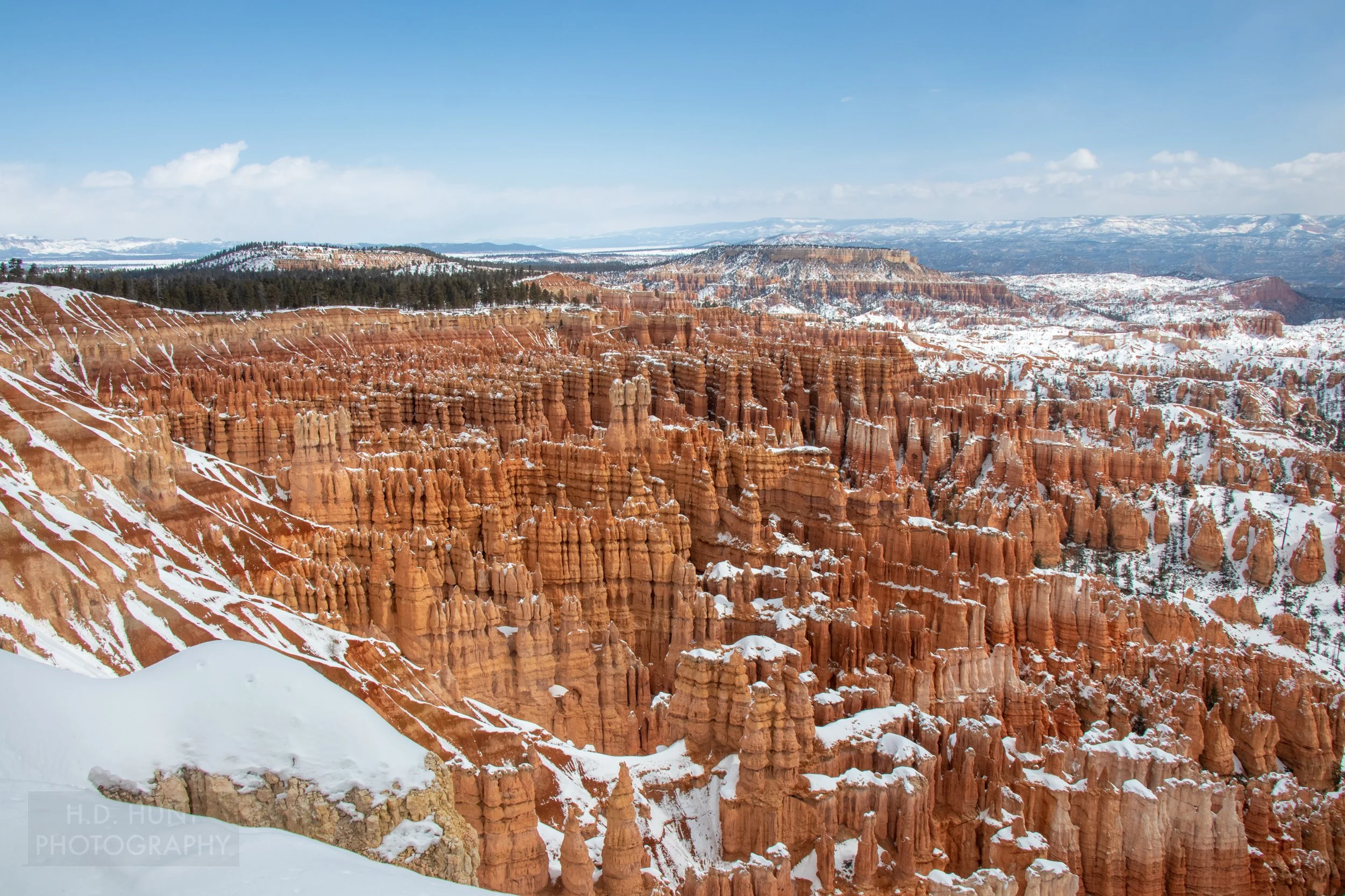
Waking on the morning of Day Four, the weather was snowy and blustery. Nonetheless, I decided to roll the dice and head north from Kanab to Bryce Canyon National Park. This one has been on my list for a long time, so I think the risk was worth it. I already knew that, given the season, most of the park would be closed. I also suspected that many of the trails that remained open would be covered in ice. I was correct, but it didn’t detract much from the experience. If anything, seeing the hoodoos surrounded by snow was amazing!
I spent a few hours in the park, starting at the Bryce Point Overlook before moving to Inspiration Point. I then took the Rim Trail from Inspiration Point to Sunset Point. This was one of the only trails still open. I returned back to the car just before a massive snowstorm rolled in.
I was only able to see a very small part of the park, and I would definitely recommend at least a full day here to see everything this park has to offer.
Ten more photographs of Bryce Canyon National Park follow.
2. Bryce Canyon National Park #2
(Click here to view a full-size version of this panorama.)
The rim at Bryce Canyon sits at an elevation of 8,000-9,000 feet / 2,400-2,700 meters.
3. Bryce Canyon National Park #3
The main feature within Bryce Canyon National Park is the canyon-like amphitheater, which initially formed as a result of headward erosion; this is where a drainage basin becomes larger in the direction opposite of the flow of the water in the basin.
4. Bryce Canyon National Park #4
Bryce Canyon is named after Ebenezer Bryce, a homesteader in the current park boundary during the late 19th century.
5. Bryce Canyon National Park #5
The Steller’s jay is the only crested bird found west of the Rocky Mountains.
6. Bryce Canyon National Park #6
Bryce Canyon’s main attraction are its hoodoos, columns of rock which have formed from rock plateaus undergoing a phenomenon called frost wedging; this is the process of water entering crevasses in the rock from rain or snowmelt then freezing, causing larger and larger cracks.
7. Bryce Canyon National Park #7
The hoodoos at Bryce Canyon undergo around 170 freeze-thaw cycles a year.
8. Bryce Canyon National Park #8
The hoodoos at Bryce Canyon can be up to 200 feet / 60 meters tall.
9. Bryce Canyon National Park #9
(Click here to view a full-size version of this panorama.)
Bryce Canyon was declared a National Monument in 1923 …
Hey, you! Enjoying this content?
Consider giving us a follow!
Thanks for the support!
10. Bryce Canyon National Park #10
… And was declared a National Park in 1928.
11. Bryce Canyon National Park #11
Bryce Canyon National Park sees over 2 million visitors a year.
12. Kodachrome Basin State Park #1
Kodachrome Basin State Park is, indeed, named after Kodachrome film.
The weather deteriorated at Bryce Canyon National Park, leading to near white-out conditions which caused us to leave the park but also limited our ability to head to our lodging in Page, Arizona. Looking at the map and the weather radar, we decided to visit Kodachrome Basin State Park, about 30 minutes to the east.
13. Kodachrome Basin State Park #2
Kodachrome Basin State Park is the only place on earth where you can see “sand pipes.”
The park is a worthwhile diversion if you are in the area, so don’t pass it up! It is a perfect complement to not only Bryce Canyon, but Grand Staircase - Escalante National Monument. After a short visit, the weather lifted and we were able to make our way to Page.
Three more photos of Kodachrome Basin State Park follow.
14. Kodachrome Basin State Park #3
15. Kodachrome Basin State Park #4
16. Kodachrome Basin State Park #5
17. Wahweep Hoodoos #1
The Wahweap Hoodoos are reached by a 9 mile / 15 kilometer round-trip hike up Wahweap Creek.
The following day, after another episode of Wave permit-related disappointment, we decided the weather was nice enough to do a hike. We chose the Wahweap Hoodoos, the trailhead of which is a short drive away from our overnight accommodations in Page.
The hike requires frequent crossings of the Wahweap Creek which on this day was icy cold from snowmelt from upstream (near Bryce Canyon, as it turns out.) The weather that day was a blessing and curse as -unlike the last few days- it was sunny and relatively warm. This worked out well, since it gave us an opportunity to dry out our shoes and socks when we arrived at the hoodoos. However, the downside was the Wahweap Creek’s water level was rising incredibly fast, and we had to cut our visit short to avoid getting stranded. I think this was a good choice, as the stream was knee-deep at the trailhead; it was just above ankle-deep that morning.
Six more photos of the Wahweap Hoodoos follow.
18. Wahweep Hoodoos #2
19. Wahweep Hoodoos #3
20. Wahweep Hoodoos #4
21. Wahweep Hoodoos #5
22. Wahweep Hoodoos #6
23. Wahweep Hoodoos #7
Comments? Recommendations? Questions?
Let us know.


